top of page

Land Surveying | Scanning | Drone Lidar
Photogrammetry | Hydrography
Our Services

Cadastral
Hart, Hutchinson & Field offers expert cadastral surveying services, providing accurate land boundary delineations for property development, legal disputes, and land management.
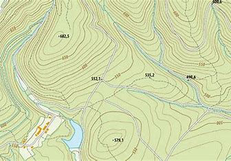
Topography
Hart, Hutchinson & Field provides expert topographic surveying services, delivering detailed and accurate mapping of land features for planning and development projects. Utilizing cutting-edge technology and precise data collection methods, our skilled surveyors produce high-quality results tailored to client needs across Barbados and the Caribbean, ensuring informed decision-making and project success.

Engineering
Precision is the foundation of every successful engineering project—and that’s exactly what we deliver. Our engineering surveying services support every phase of infrastructure and construction through the provision of accurate data for earthworks, roadways, utilities, structural layouts, and more.

Hydrography
At Hart, Hutchinson & Field, our hydrographic surveying services deliver precise and reliable data for marine and coastal projects. Utilizing advanced sonar technology and cutting-edge data processing, our experienced teams map underwater environments with exceptional accuracy. From bathymetric surveys to coastal planning, we provide tailored solutions for clients across Barbados and the Caribbean, ensuring safety, efficiency, and environmental compliance.

Drone LiDAR and Photogrammetry
Unlock the power of advanced drone technology to capture accurate, high-resolution 3D data for your large projects. Whether you're in construction, agriculture, Solar, or road design, our services provide unparalleled insights into your terrain.

3D Scanning
Unlock unmatched detail and accuracy with our advanced 3D scanning services. We use high-resolution laser scanning to capture buildings, structures, and built environments with millimeter precision to produce floor plans, elevations, sections and models to the required specifications.

Deformation Monitoring
We provide advanced deformation monitoring services for infrastructure, construction sites, natural hazard zones, and more. Using cutting-edge sensors, satellite imagery, and real-time data analytics, we help you track movement with millimeter accuracy—ensuring safety, compliance, and peace of mind.
Tell us about your project today.
bottom of page